
Canterbury - Piezometric Contours
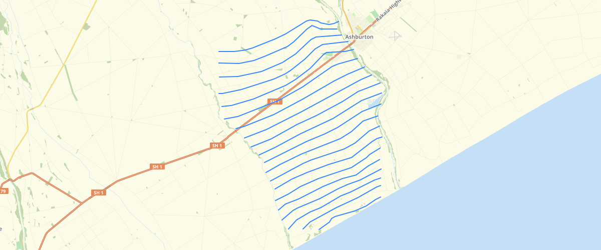
Request AccessCanterbury - Piezometric Contours - Groundwater level or piezometric surveys are a snapshot of water levels in wells (and sometimes springs and rivers) in an area at a point in time. The measurements are used to create contours of equal height above sea level, similar to topographic contours, which we call ‘piezometric contours’. Groundwater flow is perpendicular to these contours at a regional scale. Proposed disclaimer/additional information in Canterbury Maps Groundwater level or piezometric surveys are a snapshot of water levels in wells (and sometimes springs and rivers) in an area at a point in time. The measurements are used to create contours of equal height above sea level, similar to topographic contours, which we call ‘piezometric contours’. Groundwater will flow perpendicular to these contours. In using these datasets, please consider: · What scale are you interested in? Local flow paths can be very different to regional flow paths due to changes in local-scale permeability and recharge sources. Most of our contours are regional scale, and may only provide an indication of potential local flow paths. You may need to conduct your own measurements of a site to better determine local flow paths. · When was the survey undertaken? If the survey is older, it may be that local groundwater conditions have changed. There may be more than one survey of an area, and at more than one time of the year. Groundwater contours and hence flow direction can be different at times of lower and higher groundwater levels, and can depend on external factors such as stream flow and irrigation schemes. · How many wells were measured to create the contours? Contours are more reliable in areas where more wells were measured. Most of the contours have associated layers showing the wells used to create them, which may be consulted to determine local-scale reliability Canterbury Regional Council does not give and expressly disclaim any warranty as to the accuracy or completeness of the information or its fitness for any purpose. The user should independently verify the accuracy of any information before taking any action in reliance upon it.
Metadata
| Date | 12/03/2020 |
| License | CC BY 3.0 |
Sample Properties
- {} 14 keys▶
- 4553
- "Piezometric contours Ashburton Hind A2 May 2004"
- 15
- ""
- ""
- "Ashburton"
- "Ashburton"
- ""
- ""
- "Wells used in Ashburton Hinds May 2004 A2"
- "Piezometric contours"
- "Piezometric contours in metres above sea level from wells screened in what Davey (2006) refers to as 'Aquifer 2' (wells below the water table). Wells used for contouring are saved as seperate shape file."
- "Davey, G., 2006., 'The Effects of Border Dyke irrigation Recharge on Groundwater Levels in and below the Valetta Scheme' Environment Canterbury Unpublished report U06/11"
- 9855.066445185319