
Canterbury - Tsunami Evacuation Zones
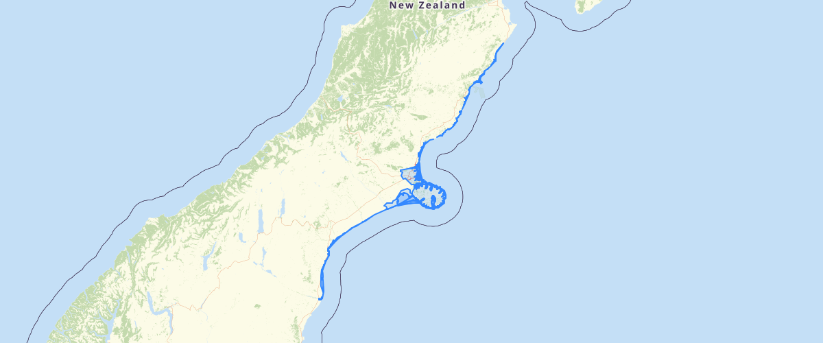
Request AccessCanterbury Tsunami Evacuation Zones - Are you in a tsunami evacuation zone? Search for your property in the address search bar, or pan around the map to see Canterbury’s tsunami evacuation zones. For more information on when and how to evacuate, see our tsunami pages on the Environment Canterbury website or contact your local emergency management officer at your city or district council. What do these zones mean? Red zone The red zone includes beaches, estuaries, harbours and river mouths. These are the areas most likely to be affected by a tsunami and that would experience the highest water depths and strongest currents. This area can be affected by small tsunamis that are unlikely to flood land but that cause strong surges or currents in the water. You should leave this zone immediately if you: feel a long or strong earthquake, OR are told to evacuate by Civil Defence, OR you hear tsunami sirens (where they are installed). Stay out of this zone until you are told it is safe to go back. You can expect to evacuate the red zone several times in your lifetime. Orange zone The orange zone is less likely to be affected by a tsunami and includes low-lying coastal areas that are likely to be flooded in a large tsunami that inundates land. You should leave this zone immediately if you: feel a long or strong earthquake, OR are told to evacuate by Civil Defence, OR you hear tsunami sirens (where they are installed). Stay out of this zone until you are told it is safe to go back. You can expect to evacuate the orange zone maybe a few times in your lifetime. Yellow zone Christchurch and Banks Peninsula also have a yellow zone, which are areas least likely to be affected by a tsunami. They could potentially be flooded in a very large tsunami coming from across the Pacific Ocean. You do not need to leave this zone if you feel a long or strong earthquake. There are no known local tsunami sources that would flood this area. If you hear tsunami sirens, turn on the radio or visit your local council's Civil Defence page. If you hear or see an announcement by Civil Defence to evacuate the yellow zone, you must leave immediately and stay out of this zone until you’re told it’s safe to go back. While it is possible you will have to evacuate this zone sometime in your lifetime, it is unlikely. Note: In most other parts of New Zealand, yellow zones need to be evacuated in a long or strong earthquake. You should check local tsunami evacuation zones when spending time on the coast. Not in a zone? If you are not in a tsunami evacuation zone you: don’t need to evacuate in a long or strong earthquake, don’t need to evacuate during a warning from Civil Defence, may wish to open your home to family or friends who need to evacuate. How are the tsunami zones drawn? What are they based on? Tsunami evacuation zones are areas that we recommend people evacuate from as a precaution after they feel a long or strong earthquake, or in an official tsunami warning. They encompass many different possible tsunami scenarios. The area that would be flooded in any particular tsunami depends on many factors, including: the size of the earthquake precisely how the earthquake fault moved the direction the tsunami is coming from the tide level when the largest waves arrive. Every tsunami will be different and we can never say for sure exactly which areas within a zone will be flooded. There is no one tsunami that would flood an entire zone. We consider many different tsunami scenario models when drawing the tsunami evacuation zones. The inland boundary of the zones is based on several ‘worst-case’ scenarios – tsunamis that we might expect once every 2500 years. The alternative to this approach is to have hundreds of different evacuation zones for hundreds of possible tsunami scenarios, which would be really confusing and hard to communicate. The zone boundaries, particularly in urban areas, usually follow some sort of feature that is easy to see on the ground, like roads, so that you easily know whether you are in or out of the zone. We also consider the locations of schools, rest homes and parks. For example, if part of a park could be flooded in a tsunami, we will generally include the whole park in the evacuation zone, as it is much easier to simply close an entire park, rather than just part of it. You can download our report Review of tsunami evacuation zones for Christchurch City <link to PU1C/8670>, which describes how the Christchurch City zones were drawn and the models that they are based on. Tsunami evacuation zones in other parts of Canterbury will be reviewed using the results of modelling being done in 2019 and 2020.
Metadata
| Date | 03/12/2019 |
| License | CC BY 3.0 |
Sample Properties
- {} 13 keys▶
- 1
- "Orange"
- "Hurunui"
- "Evacuate if you feel a long (more than a minute) OR strong (hard to stand up) earthquake, or if you are told to in an official tsunami warning."
- "Canterbury Maps Partners"
- "2016-11-03T00:00:00.000Z"
- 2843.43249065
- ""
- ""
- "1970-01-01T00:00:00.000Z"
- ""
- 255248.27411615016
- 28434324.925990842