
BoP Tsunami Evacuation Zone
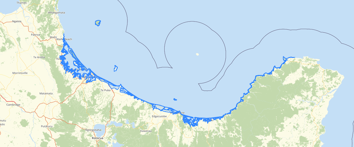
Request AccessUpdated in September 2016. The layer shows the Tsunami Evacuation Zone Level 2 and Level 3. Level 3 covers the area of coastline extending from the mouth of thw Waiora River west of Tauranga City to the mouth of the Maketu Estuary in the east. The rest of the areas in the BOP are level 2. Level 3 is based on high-resolution inundation modelling of a ‘maximum credible tsunami’ event originating from the Kermedec Trench. Offshore tsunami conditions are based on model outputs from GNS Science. The tsunami is transformed to shore and its flow across land and into the harbour modelled using a high-resolution (10 m) domain. A tidal level equivalent to Mean High Water Spring is assumed at the time of Tsunami impact. * as defined in Tonkin & Taylor (April 2015) Tsunami Evacuatio Route Planning For Tauranga City. Level 2 Tsunami Inundation Zones created using the 2mDEM resampled to 4m. The RED zone covers all land areas below the calculated regional average of Mean High Water Spring* (0.8958m elevation) and extending to 10 meters inland. The ORANGE Zone caovers all areas from the inland boundary of the RED zone to the expected maximum extent** of a 4m tsunami wave with expected run-up to 8m from Waihi Beach to Otamarakau, BOP WEST and; of a 5m tsunami wave with expected run-up to 10m from Otamarakau to Cape Runaway, BOP EAST. The YELLOW zone extends from the ORANGE boundary to expected maximum extent** of a 6.75m tsunami wave with expected run-up to 13.5m for BOP WEST and; of an 8.25m tsunami wave with expected run-up to 16.5m for BOP EAST. * as defined in page 18, MHWS level for the Bay of Plenty, NIWA Client Report HAM2006-133 Oct 2006, NIWA Project BOP07212 ** The recommended attenuation rule of 1metre decrease in wave height every 200 metres inland was applied for calculating how far the tsunami wave travels inland. The attenuation rule for the river, 1m decrease for every 400m distance upriver, was aplied to determine the maximum distance travelled by the modelled tsunami waves (run-up of 8 and 13.5m travelling a maximum of 3200m and 5400m, respectively upriver). - Tsunami Evacuation Zones Director's Guideline for Civil Defence Emergency Management Groups [DGL 80/80] December 2008 ISBN 978-0-478-25483-9
Metadata
| Provider | Bay of Plenty Regional Council Toi Moana |
Sample Properties
- {} 5 keys▶
- 1
- 192617119.27779174
- 1787246.0727002241
- "Orange"
- 1