
Hawkes Bay Wairoa River Bank Stability Offset Boundaries
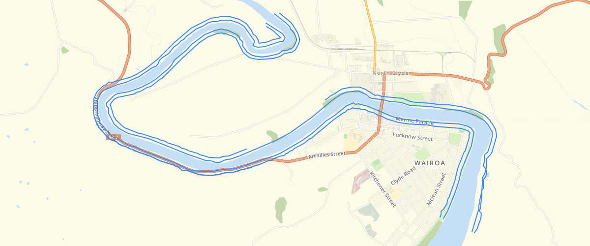
Request AccessIn 2009 Tonkin & Taylor Ltd were engaged by Hawke’s Bay Regional Council to undertake a preliminary assessment of the bank stability over a 12km reach of the lower Wairoa River, extending from approximately 3km downstream to 9km upstream of the SH2 bridge in Wairoa town.The purpose of the study is to provide a preliminary assessment of the existing condition and medium- to long-term stability of the banks to assist HBRC in setting hazard lines along the river for planning purposes. It involved 3 stages:- Desk study- Site Inspection and mapping- Assessment and reportingInspections of the river banks suggest that the slopes have largely reached a stable morphology under normal conditions (i.e. excluding extreme storm/flood and/or seismic events) with slope gradients generally in the 20 to 30° range. However, ongoing erosion of the river banks, both under normal flow conditions and during high flow events, is likely to result in a loss of toe support, resulting in further instability of the slopes. At the lower end of the river, particularly around Wairoa town and further downstream, the near surface subsoils contain a significant proportion of fine-grained material and tends to behave as cohesive deposits. Ongoing erosion in these areas leads to relatively small scale ‘undrained’ rotational failures. These are most likely to occur when the ground is fully saturated and the river water level drops quickly in response to tidal variations (rapid drawdown mechanism). Further upstream, the proportion of fine grained material reduces and the slopes behave more in a ‘drained’ manner. Erosion of the lower banks in these areas therefore precipitates relatively shallow, but more extensive, surface failures.The banks were categorised, based on the assumed level of hazard; low, medium and high. These relate to the likelihood of the ground being affected by bank instability within the next 50 years. - Low: The risk of instability is considered to be low or negligible - Medium: There is a moderate chance of instability affecting this zone within 50 years requiring careful development.- High: Existing instability of ground within this zone and/or high level of risk of further instability within 50 years. This zone may be considered unsuitable for development unless works are undertaken to avoid, remedy or mitigate the hazard. The hazard assessment does not take into account the likely impact of the instability in terms of the existing or proposed land use. The significance of instability will be greater in some areas, particularly the town centre, residential and industrial areas when compared to rural and conservation/reserves, but the impact on any individual development within those zones will be similar.The categories are provided principally to assist Wairoa District Council in determining the appropriate level of geotechnical assessment required for any proposed development within those zones.
Metadata
| Date | January 29, 2020 |
| License | No License Provided |
Sample Properties
- {} 3 keys▶
- "75m offset from river boundary"
- 2810.424401486631
- 1